Abstract:
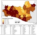
This study aims to analyze how the influence of infrastructure availability, socioeconomic conditions, and the effect of location on poverty levels. The descriptive analysis is used to give a general description of poverty by using thematic charts and maps. The poverty map is analyzed by spatial autocorrelation of poverty levels by using a Moran Scatterplot and the Local Indicators of Spatial Association (LISA) Map. The results of the study indicate the existence of spatial linkages to poverty. The Increasing of other variables outside the model in neighboring regions will increase the level of poverty in a region. The infrastructures of road extension, clean water infrastructure, economic growth, quality of education, and health have a significant influence on the level of poverty, while the percentage of satisfactory sanitation did not demonstrate to affect the significant effect on poverty. The conclusion is that the level of poverty in the provinces of Central Java and Yogyakarta has an irregular distribution and a clustered spatial pattern.
Keywords:
level of poverty; spatial model; spatial regression analysis
 Thumbnail
 Thumbnail
 Thumbnail
 Thumbnail


