
Abstract
Human activity has prompted a rapid decline in the forested areas of the Amazon, resulting in an increase in the number of isolated forest fragments. Belém is the smallest and most deforested area of endemism in the biome. Its high level of degradation translates into great biodiversity vulnerability and the need for urgent measures to address these changes. The aim of this research was to analyze connectivity among the Belém’s remaining forest fragments and to classify them according to their importance for population dispersal. We used morphological spatial pattern analysis to characterize landscape structure and the integral index of connectivity to defi ne the importance of forest fragments. From a structural perspective, 55.28% of the forested area was classifi ed as core, 16.88% as edge. From a functional perspective, few fragments were classifi ed as highly important. In general, larger fragments were more important for connectivity. The protected areas seem to not have considered the forest connectivity in their planning, although the designation of priority areas has valued this variable. This study provides an important theoretical outline for considering connectivity in the planning phase and represents a contribution to more detailed research on how to maintain biodiversity in the Belém Area of Endemism.
Key words
Amazon; connectivity; fragmentation; protected areas
INTRODUCTION
Changes in landscape structure have attracted researchers’ attention over the last few decades because human activity has caused a rapid reduction in areas of native vegetation and converted rich and diverse landscapes into isolated fragments (Pereira et al. 2001PEREIRA JLG, BATISTA GT, THALES MC, ROBERTS D & VENTURIERI A. 2001. Métricas da paisagem na caracterização da evolução da ocupação da Amazônia. Geografia 26(1): 59-90., Jesus et al. 2012JESUS FM, PIVELO VR, MEIRELLES ST, FRANCO GADC & METZGER JP. 2012. The importance of landscape structure for seed dispersal in rain forest fragments. J Veg Sci 23(6): 1126-1136). These changes have reduced the size of the available habitat and negatively affected the connectivity between forest fragments (Pascual-Hortal & Saura 2006PASCUAL-HORTAL L & SAURA S. 2006. Comparison and development of new graph-based landscape connectivity indices: towards the priorization of habitat patches and corridors for conservation. Landscape Ecol 21(7): 959-967.). The conservation of landscape connectivity is essential to maintain important ecological functions, such as animal dispersal and the genetic flow of populations (Crist et al. 2005CRIST MR, WILMER B & APLET GH. 2005. Assessing the value of roadless areas in a conservation reserve strategy: biodiversity and landscape connectivity in the northern Rockies. J Appl Ecol 42(1): 181-191.), factors which make such study an essential theme for conservation biology (Calabrese & Fagan 2004CALABRESE JM & FAGAN WF. 2004. A comparison-shopper’s guide to connectivity metrics. Front Ecol Environ 2(10): 529-536.)
Maintaining connectivity between habitat fragments is one of the most important strategies for the conservation of biodiversity (Saura & Pascual-Hortal 2007SAURA S & PASCUAL-HORTAL L. 2007. A new habitat availability index to integrate connectivity in landscape conservation planning: Comparison with existing indices and application to a case study. Elsevier. Landsc Urban Plan 83(2-3): 91-103.), and measures of connectivity are thus used as a basis for the decision-making process (Calabrese & Fagan 2004CALABRESE JM & FAGAN WF. 2004. A comparison-shopper’s guide to connectivity metrics. Front Ecol Environ 2(10): 529-536.). Connectivity between areas can be divided into two types: structural, which describes physical connections between fragments, such as the distance between them and the existence of corridors; and functional, which covers the capacity for species dispersal across different elements of the landscape (Forrero-Medina & Vieira 2007). Thus, connectivity can be seen as an independent variable affecting ecological processes and populations, and as a variable dependent on species’ behavior and landscape structure (Goodwin 2003GOODWIN BJ. 2003. Is landscape connectivity a dependent or independent variable? Landscape Ecol 18: 687-699.).
The study of structural connectivity involves the recognition of different elements in the landscape, such as core areas, borders, corridors, islets and perforations (Soille & Vogt 2009SOILLE P & VOGT P. 2009. Morphological segmentation of binary patterns. Pattern Recognit Lett 30(4): 456-459.), whose existence, size and spatial configuration contribute to the maintenance of connector functions. The characteristics and distribution of these elements guide estimation of the relative importance of different areas, enabling the conservation of patches of habitat that are fundamental connectors. The use of this approach in parallel with analyses that involve the potential for species dispersal is an important strategy to mitigate the loss of biodiversity caused by fragmentation (Pascal & Saura 2006).
A review performed in 2003 about research on landscape ecology showed that connectivity was studied mainly as an independent variable until the year 2000 (Goodwin 2003GOODWIN BJ. 2003. Is landscape connectivity a dependent or independent variable? Landscape Ecol 18: 687-699.). However, the use of this approach alone is not very robust, as it cannot reflect the real capacity of organisms to move around the landscape (Goodwin 2003GOODWIN BJ. 2003. Is landscape connectivity a dependent or independent variable? Landscape Ecol 18: 687-699.). Therefore, in addition to the analysis of structural connectivity, recognition and expression of the movement of species in response to changes in the landscape have become important to acquire parameters enabling the classification of areas into contribution levels for overall connectivity (Crouzeilles et al. 2013CROUZEILLES R, LORINI ML & GRELLE CEV. 2013. The importance of using sustainable use protected areas for functional connectivity. Biol Conserv 159: 450-457.). The use of indexes that link landscape metrics to the species dispersal capacity is an alternative that has been adopted widely to study functional connectivity (Forero-Medina & Vieira 2007FORERO-MEDINA G & VIEIRA MV. 2007. Conectividade funcional e a importância da interação organismo-paisagem. Oecol Bras 11(4): 493-502.).
Different indices have been developed to measure a landscape’s isolation or connectivity among habitat patches within the landscape, however many of these are redundant and imprecise (Forero-Medina & Vieira 2007FORERO-MEDINA G & VIEIRA MV. 2007. Conectividade funcional e a importância da interação organismo-paisagem. Oecol Bras 11(4): 493-502.). The integral index of connectivity (IIC) is considered to be one of the most robust indexes because it reacts to all types of landscape change in a consistent and desirable way (Forero-Medina & Vieira 2007FORERO-MEDINA G & VIEIRA MV. 2007. Conectividade funcional e a importância da interação organismo-paisagem. Oecol Bras 11(4): 493-502.). This index is based on graph theory and uses the size, proximity and topology of the fragments as parameters (Pascal & Saura 2006). These properties make the analysis more sensitive to spatial patterns and enable the creation of models that link species dispersal capacity to the landscape’s spatial structure (Pascal & Saura 2006).
Research has revealed a strong relationship between landscape spatial structure and population size (Fahrig 1998FAHRIG L .1998. When does fragmentation of breeding habitat affect population survival? Ecol Model 105(2-3): 273-292, Prist et al. 2012PRIST PR, MICHALSKI F & METZGER JP. 2012. How deforestation pattern in the Amazon influences vertebrate richness and community composition. Landscape Ecol 27(6): 799-812.). For populations in which the proportion of available habitat exceeds the 30% of the landscape, population size is related to the area of the patches (Andrén 1994ANDRÉN H. 1994. Effects of habitat fragmentation on birds and mammals in landscapes with different proportions of suitable habitat: a review. Oikos 71(3): 355-366., Fahrig 1998); in landscapes where the quantity of habitat is below this threshold, the configuration of fragments affects population and community patterns more intensely. These factors strengthen the importance of analyzing spatial structure in the context of biodiversity conservation (Andrén 1994ANDRÉN H. 1994. Effects of habitat fragmentation on birds and mammals in landscapes with different proportions of suitable habitat: a review. Oikos 71(3): 355-366., Fahrig 1998, Prist et al. 2012PRIST PR, MICHALSKI F & METZGER JP. 2012. How deforestation pattern in the Amazon influences vertebrate richness and community composition. Landscape Ecol 27(6): 799-812.). Despite the existence of an extensive body of literature showing the influence of landscape structure on conservation, few studies have discussed the consequences of this variable to the maintenance of biodiversity in areas of tropical forest (Prist et al. 2012PRIST PR, MICHALSKI F & METZGER JP. 2012. How deforestation pattern in the Amazon influences vertebrate richness and community composition. Landscape Ecol 27(6): 799-812.).
In the Brazilian Amazon, the world’s largest tropical forest, intense deforestation is currently ongoing (Arima et al. 2005ARIMA EY, WALKER RT, PERZ SG & CALDAS M. 2005. Loggers and Forest Fragmentation: Behavioral Models of Road Building in the Amazon Basin. Ann Assoc Am Geogr 95(3): 525-541.). It has been responsible for various negative effects on forest life (Laurance et al. 2002LAURANCE WF ET AL. 2002. Ecosystem decay of Amazonian forest fragments: a 22-year investigation. Biol Conserv 16(3): 605-618.). Many taxa in this region are not distributed widely, but occur in areas of limited endemism, which, in many cases, makes them unique and irreplaceable (Silva et al. 2005SILVA JMC, RYLANDS AB & FONSECA GAB. 2005. O destino das áreas de endemismo da Amazônia. Megadiversidade 1(1): 125 -129.). Studies of these areas of the Amazon are of the utmost importance in the context of the loss of biodiversity, as they considered to be the smallest biogeographic units common to many species (Cracraft 1985CRACRAFT J. 1985. Historical biogeography and patterns of differentiation within the South American avifauna: areas of endemism. Ornith Monographs 36: 49-84.).
Belém is the smallest and most deforested area of endemism in the Amazon. It shelters many of the animal and vegetable species on the State of Pará’s list of species threatened with extinction (SEMAS 2016SEMAS – SECRETARIA DE MEIO AMBIENTE. 2016. Espécies Ameaçadas. Disponível em <<http://www.sema.pa.gov.br/2009/03/27/9439/>>. Acessado em 22 de março de 2016.
http://www.sema.pa.gov.br/2009/03/27/943...
). It has two distinct regions in terms of the dynamics of land use. One region (the Bragantine zone) is located north of the Guamá river, with more than a century of use, and the other region (the Pará Salgado) is south of the Guamá River and has a more recent history (30-50 years) of land use (Almeida & Vieira 2010). The high level of degradation in the Bragantine zone is the result of an older process of occupation and land use for lumber resource exploitation and agricultural activities, which generally occur without the authorization of the management responsible entities (Almeida & Vieira 2010). This scenario reveals the great vulnerability of the landscape need for urgent measures to address the changes induced by human activity to the forest (Silva et al. 2005SILVA JMC, RYLANDS AB & FONSECA GAB. 2005. O destino das áreas de endemismo da Amazônia. Megadiversidade 1(1): 125 -129.).
The creation of a system of protected areas is one strategy to neutralize or weaken the impact of regional plans for development, such as the increase of agricultural land, urbanization and infrastructure constructions. However, these areas need to be chosen in a responsible way, creating core areas to preserve biodiversity and to maintain genetic and population flows to other areas (Silva et al. 2005SILVA JMC, RYLANDS AB & FONSECA GAB. 2005. O destino das áreas de endemismo da Amazônia. Megadiversidade 1(1): 125 -129.). For this purpose, the incorporation of landscape metrics and maintenance of connectivity in the spatial prioritization of the areas for conservation is fundamental, as they provide the theoretical and empirical basis for the promotion of species persistence and the evolutionary processes in a region (Forrero-Medina & Vieira 2007).
In light of the need to conserve the remaining forests in the Belém area of endemism (BAE), the study of landscape connectivity can help define key areas for conservation and environmental restoration (Goodwin & Fahrig 2002GOODWIN BJ & FAHRIG L. 2002. How does landscape structure influence landscape connectivity? Oikos 99(3): 552-570.). In this article, we examine the connectivity of forest remnants in the BAE. We identify priority fragments for the maintenance of connectivity and propose conservation strategies. First, we classified and measured the fragments based on the elements that make up the landscape. Then, we evaluated the connectivity of this landscape based on the connectivity indexes. Finally, we evaluate the conservation scenario of the current network of protected areas in the BAE, compared proposals for ecological corridors based on the priority areas map, identified key fragments for the maintenance of connectivity in the study area, and compared our simulated scenario with that of the priority areas map.
MATERIALS AND METHODS
Study area and database
The BAE occupies 243,752.18 km2 in the northeast of the Eastern Amazon, between the latitudes of 0.5°S and 6.0°S and longitudes of 44.0°W and 50.0°W. Its limits are determined by natural barriers, such as the Tocantins River to the west and the Pindaré River to the east.
The study area has vegetation comprised mainly of dense rainforest, which represents the fragments that we considered as potential habitat. We adopted a binary characterization of the soil cover as habitat (natural forest) and non-habitat (other classes of cover) in our conceptual model. The soil cover map defining areas of native forest vegetation corresponds to the year 2010 and was obtained from the TerraClass project (INPE 2015). This map was derived from the classification of Landsat 5TM satellite images in the Lat/Long Projection System and the SAD 69 Geodetic Reference System to form a mosaic covering the states of Pará, Maranhão and Tocantins. We extracted the BAE from the forest vegetation map, selecting only fragments of natural forest with areas > 50 ha.
Within these limits is a complex of protected areas that includes 27 conservation units and 18 indigenous land areas, which differ in terms of the protection systems that regulate them (MMA 2015MMA – MINISTÉRIO DO MEIO AMBIENTE. 2015. Unidades de conservação. Acessado em 21 de setembro de 2015. Disponível em <<http://mapas.mma.gov.br/i3geo/datadownload.html>>.
http://mapas.mma.gov.br/i3geo/datadownlo...
). For this study, we used the map of protected areas (declared and regulated areas of conservation and indigenous land) provided by the Ministério do Meio Ambiente (MMA 2007MMA – MINISTÉRIO DO MEIO AMBIENTE. 2007. Áreas Prioritárias para Conservação, Uso Sustentável e Repartição de Benefícios da Biodiversidade Brasileira: Atualização - Portaria MMA n°9, de 23 de janeiro de 2007. Secretaria de Biodiversidade e Florestas. – Brasília, p. 29-38.).
Morphological Spatial Pattern
We performed a structural classification of the landscape using the morphological spatial pattern analysis (MSPA) instrument, which consists of a personalized sequence of mathematical operators drawn from the description of the geometry of connectivity among the landscape elements (Soille & Vogt 2009SOILLE P & VOGT P. 2009. Morphological segmentation of binary patterns. Pattern Recognit Lett 30(4): 456-459.). Based on a geometric concept, MSPA results in the classification of fragments into seven categories: (i) core, a fragment area that excludes the edge; (ii) islet, a small fragment with no core area; (iii) loop, an area that connects the same fragment; (iv) corridor, an area that connects different fragments; (v) perforation, the internal edge of a fragment; (vi) edge, the perimeter of a fragment; and (vii) branch, an area that connects non-core elements. We defined the thickness of the fragment edge as 300 m to represent the distance at which the greater part of the changes in biota occur (Laurance et al. 2002LAURANCE WF ET AL. 2002. Ecosystem decay of Amazonian forest fragments: a 22-year investigation. Biol Conserv 16(3): 605-618.). We executed MSPA using the Guidos Toolbox package (Soille & Vogt 2009SOILLE P & VOGT P. 2009. Morphological segmentation of binary patterns. Pattern Recognit Lett 30(4): 456-459., Vogt & Riitters 2017VOGT P & RIITTERS K. 2017. GuidosToolbox: universal digital image object analysis. Eur J Remote Sens 50(1): 352-361.).
Analysis of functional connectivity
For the analysis of connectivity, we used the IIC, which uses a potential dispersal distance to rank fragments according to their importance to the landscape’s connectivity. The IIC consists of three sub-indexes: the IIC-Intra evaluates a fragment’s internal contribution based on its area; the IIC-Flux analyzes dispersal flow, considering the location of a fragment within the network of fragments, based on its area; and the IIC-Conn indicates the fragment’s contribution as a linking element, using only its topology (Saura & Rubio 2010SAURA S & RUBIO L. 2010. A common currency for the different ways in which patches and links can contribute to habitat availability and connectivity in the landscape. Ecography 33(3): 523-537.). We used 800 and 3300 m as dispersal values to estimate connectivity for species with moderate and high dispersal capacities, respectively (Umetsu et al. 2008UMETSU F, METZGER JP & PARDINI R. 2008. Importance of estimating matrix quality for modeling species distribution in complex tropical landscapes: a test with Atlantic forest small mammals. Ecography 31(3): 359-370., Jesus et al. 2012JESUS FM, PIVELO VR, MEIRELLES ST, FRANCO GADC & METZGER JP. 2012. The importance of landscape structure for seed dispersal in rain forest fragments. J Veg Sci 23(6): 1126-1136). In this study, we used the delta integral index of connectivity (dIIC), which characterizes the relative importance computed for each node given by the variation in the IIC. The dIIC and dIIC-Intra, dIIC-Flux and dIIC-Conn sub-indexes provided delta values that facilitated comparison and use of the resulting information in the development of conservation and management plans. The forest fragments were grouped into five hierarchical classes, in the various sub-indices and different dispersal capacities, using Jenks natural breaks optimization (Jenks & Caspall 1971JENKS GF & CASPALL FC. 1971. Error on choroplethic maps: definition, measurement, reduction. Ann Assoc Am Geogr 61(2): 217-244.), also known simply as “natural breaks.” Class 1 was the most important and class 5 was the least important; we considered fragments in classes 1, 2 and 3 to be the most important. We quantified the proportion of protected areas in each functional connectivity class to evaluate the connectivity of the protected areas of the BAE. We also developed classification of the fragments in an alternative scenario, in which we excluded the two largest fragments, in order to observe the changes in the classification of importance by “natural breaks”. The values of the indicated dIIC for the fragments (dispersal: 800m) were the target of this last classification. This scenario was simulated only for the dispersal capacity of 800 m because that the distance mentioned is not a barrier for species with dispersal 3300m.
Comparison of ecological corridors proposals
We analyzed the overall connectivity index (dispersal: 800 m) of the landscape in three distinct scenarios: the first represented by the current spatial arrangement of the forest fragments; the second scenario corresponds to the representation of the current forests with the inclusion of corridors proposed by the updated map of priority areas for the conservation of the Amazon (MMA 2007MMA – MINISTÉRIO DO MEIO AMBIENTE. 2007. Áreas Prioritárias para Conservação, Uso Sustentável e Repartição de Benefícios da Biodiversidade Brasileira: Atualização - Portaria MMA n°9, de 23 de janeiro de 2007. Secretaria de Biodiversidade e Florestas. – Brasília, p. 29-38.); while the third scenario consists of the current arrangement of forest fragments with the inclusion of our proposal to create corridors. In our proposal, we created vectors to connect the fragments with a large area and generated a buffer of 400 meters for both sides of the vectors with the intention of producing continuous area with at least 800 meters of thickness. We then compared the changes in connectivity and the between the three scenarios.
Indications for the designation of priority areas for Amazon conservation
We grouped fragments that presented high levels of connectivity (classes 1–3) in at least one of the two dispersal scenarios. The outline of these fragments served as the basis for the definition of key fragments to improve connectivity between protected areas and to identify priority areas for conservation from the perspective of the functional connectivity of the regional landscape. Finally, we developed a map showing the relative importance of the fragments, as classified by the dIIC, and the priority areas for conservation identified by the Brazilian government in 2006 (MMA 2007MMA – MINISTÉRIO DO MEIO AMBIENTE. 2007. Áreas Prioritárias para Conservação, Uso Sustentável e Repartição de Benefícios da Biodiversidade Brasileira: Atualização - Portaria MMA n°9, de 23 de janeiro de 2007. Secretaria de Biodiversidade e Florestas. – Brasília, p. 29-38.).
RESULTS
We identified 5098 fragments of forest with areas > 50 ha, with a total area > 7 million hectares and comprising nearly 28% of the total area BAE. Most fragments are small (63.5% are < 200 ha), and two fragments together make up nearly half (46.6%) of the total area of these remnants.
In the analysis of landscape structure, 55.28% of the forested area was defined as core, 16.88% as edge and 2.07% as perforations in the core areas. The remaining areas (25.77%) were defined as connectors (corridor, loops, branches and islets). In both scenarios (800 and 3300 m), the proportion of the core areas exceeded that of other structures identified by MSPA in fragments in classes 1–4. In class 5 fragments, the proportion of edge areas was approximately the same as or exceeded the percentage of core area (Figure 1).

Proportion and classification of the forest remnants for the Belém area of endemism based on the MPSA analysis.
In general, fragments with larger areas were of greater importance to connectivity (Figures 2 and 3). The 3300-m dispersal scenario favored fragments that were further from the center of the BAE (Figure 4), as they were better classified than in the 800-m dispersal scenario, as in the case of shoreline fragments and the southeastern portion of the area. Few fragments, in both dispersal scenarios, were classified as highly important (classes 1–3)(Table I).

Relationship between the size of the fragments in the Belém area of endemism and the importance given to them by each index (800m dispersal).
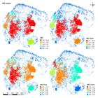
Model with the classification of the fragments of the Belém area of endemism on each index and sub-index for landscape connectivity (dispersal distance of 800 meters).

Model with the classification of the fragments of the Belém area of endemism on each index and sub-index for landscape connectivity (dispersal distance of 3300 meters).
Table I. Quantity of fragments for the Belém area of endemism as classified by the dIICindex 800 and 3300 meters.
The two largest fragments in the BAE were identified as most important (class 1) in both dispersal scenarios. In the 800-m dispersal model, the dIIC-Intra, dIIC-Flux, and dIIC-Conn assigned 4, 16, and 7 fragments, respectively, to classes 1–3 (Table I). Corresponding numbers for the 3300-m dispersal model were 5 (those with the largest areas), 25, and 10, respectively. The removal of the two largest fragments of the central region promoted some changes in the importance of the other fragments of the BAE: fragments of the northwest region became the most important; the large fragment of the southeast region lost its importance for connectivity and some fragments of the coast improved their classification (Figure 5a).

(a) classification of fragments in an alternative scenario in which the two largest fragments were excluded. (b) Proposals to create an ecological corridor: developed by the Brazilian government (corridor 1); and that developed in our research (corridor 2).
The proposal of ecological corridors developed by the Brazilian government and our proposal increased the value of general connectivity of the landscape (current landscape: overall IIC = 2716822; proposal of corridors of the event to select priority areas: overall IIC = 46985670000; our proposed corridors: overall IIC = 48977460000), however our proposal required substantially less area (proposal of the event to select priority areas: 1869393.28 hectares; our proposed corridors: 33344.68 hectares.) for the production of ecological corridors (Figure 5b).
In total, 29.64% of the forest area of the BAE already has some protection, the largest part of which is indigenous land (Table II; Figure 6). However, these protected areas were not selected based on their value to connectivity. For both dispersal distances, the protected areas are not primarily made up of class 1 fragments, and only 1% of area of the class 2 fragments are already protected. No protection has been established for important areas in the central region of the BAE and in other areas connecting these fragments to the coast and to the western region of the study area. The southern part of the BAE has large protected areas disconnected from each other (dIIC-Conn class 5). However, the indication of the map of priority areas for Amazon conservation, performed by the Ministry of the Environment, suggested corridors and indicated different areas with high connectivity (Figure 7).

Map with the definition of the priority areas for connectivity and protected areas in the Belém area of endemism. PA - protected areas.

Relationship between the importance attributed by the IIC (800m) for the Belém area of endemism and the actions suggested on the priority areas for Amazon conservation indicated by the Brazilian government in 2006. PA - protected areas.
Proportion of the protected areas based on their importance on the connectivity index. SUPA – Sustainable Use Protected Areas; IPPA – Integral Protection Protected Areas ; BAE – Belém Area of Endemism.
DISCUSSION
The MSPA and IIC provided complementary characterizations of connectivity in the BAE, indicating a situation of advanced degradation with few large remnants and forested areas with low connectivity. They also enable the identification of ecological corridors and the development of different conservation strategies based on connectivity sub-index values.
The BAE has two large central fragments that are important to conservation. Based on the theory of insular biogeography (MacArthur & Wilson 1967MACARTHUR RH & WILSON EO. 1967. The theory of island biogeography. Princeton, N.J.: Princeton University Press, 201 p.), which states that species richness is directly proportional to area and indirectly proportional to the distance between islets, we can infer that these fragments harbor a rich diversity of environments and species. These fragments also have configurations with good proportion between the perimeter and the area, which minimizes disturbances related to the edge effect (Odum & Barrett 2008ODUM EP & BARRETT GW. 2008. Ecologia da Paisagem - Fundamentos de Ecologia. Cengae Learning, 5ª ed., São Paulo, 612 p.). In addition, as metapopulation theory predicts (Levins 1969LEVINS R. 1969. Some demographic and genetic consequences of environmental heterogeneity for biological control. Bulletin Entomol Soc Am 15(3): 237-240.), these fragments probably function as source areas for the small fragments around them, which highlights their importance to conservation. Based on the neutral theory of biodiversity, we can also infer that changes in the size and distance between these fragments will directly influence species composition, as the stochastic processes that determine the variation in (ecologically derived) population abundance would be compromised by a lack of connectivity within the network of fragments (Hubbell 2001HUBBELL SP. 2001. The unifield neutral theory of biodiversity and biogeography. Pricenton University Press, 1st ed., 392 p.). The species extinction process would probably also be characterized by changes to the landscape’s spatial configuration, as has been observed in other tropical regions with species adapted to large areas (Odum & Barret 2008).
Along the whole length of the BAE, we identified large numbers of stepping stones and ecological corridors, which indicates an advanced process of fragmentation, but one that can be reversed if these areas are preserved and parts of them recovered. Conservation of these areas should be considered when developing ecological plans for the region because they can contribute to the regulation of the rate of migration between core areas and enable maintenance of the rescue effect (Levins 1969LEVINS R. 1969. Some demographic and genetic consequences of environmental heterogeneity for biological control. Bulletin Entomol Soc Am 15(3): 237-240.), thereby reducing the possibility that populations in decline will become extinct.
In analyzing functional connectivity, we verified the influence of dispersal distance on fragment connectivity. The model with the greater dispersal distance (3300 m) yielded more fragments in classes of greater importance. The two largest fragments were important for species with different dispersal capacities (800 and 3300 m), mainly due to the maintenance of high internal connectivity. Changes in the structure of these fragments could influence species with 3300-m dispersal, such as some large mammals, and disturb the ecosystem (Jesus et al. 2012JESUS FM, PIVELO VR, MEIRELLES ST, FRANCO GADC & METZGER JP. 2012. The importance of landscape structure for seed dispersal in rain forest fragments. J Veg Sci 23(6): 1126-1136). Both fragments also showed high importance for connectivity for populations with an 800-m dispersal distance, such as birds and small mammals, which are also important for the dispersal of seeds (Umetsu et al. 2008UMETSU F, METZGER JP & PARDINI R. 2008. Importance of estimating matrix quality for modeling species distribution in complex tropical landscapes: a test with Atlantic forest small mammals. Ecography 31(3): 359-370., Jesus et al. 2012JESUS FM, PIVELO VR, MEIRELLES ST, FRANCO GADC & METZGER JP. 2012. The importance of landscape structure for seed dispersal in rain forest fragments. J Veg Sci 23(6): 1126-1136). Despite differences in dispersal capacity, species respond in the same way to changes in landscape structure, intensifying the pressure to create protected areas (Crouzeilles et al. 2014CROUZEILLES R, PREVEDELLO JA, FIGUEIREDO MSL, LORINI ML & GRELLE CEV. 2014. The effects of the number, size and isolation of patches along a gradient of native vegetation cover: how can we increment habitat availability? Landscape Ecol 29: 479-489.).
The comparison between the general connectivity of the landscape in different scenarios to creating ecological corridors indicated that our proposal has increased the connectivity based in a smaller amount of area for the creation of ecological corridors, reducing the total cost of implementation. Researches point to the cost variable as one of the influential factors in implementing conservation plans (Knight et al. 2009KNIGHT AT, COWLING RM, DIFFORD M & CAMPBELL BM. 2009. Mapping human and social dimensions of conservation opportunity for the scheduling of conservation action on private land. Conserv Biol 24(5): 1348-1358.). Therefore, our design of ecological corridors, in terms of cost, can be an interesting alternative to improve the connectivity of the landscape, considering the limited resources, the urgency in reducing the biodiversity erosion, and the need of conservation actions with minimal impact over other economic activities in the region. However, other concerns should be taken into account in conservation decisions involving corridor establishment. The longer corridors included in the government proposal will inevitably mean more area for the species. Although more area does not always translate into effective conservation it is normally important, especially in fragmented areas or places with high human pressure. Therefore, the best only can be properly evaluated by monitoring outcomes of applying these different strategies in the field.
The creation of protected areas in the Amazon, in which the BAE is situated, has occurred mainly as a result of government plans, which have prioritized areas of biological and cultural importance and of natural beauty, or sought to assure the sustainable use of natural resources by traditional populations (Schulmann 2007, MMA 2015MMA – MINISTÉRIO DO MEIO AMBIENTE. 2015. Unidades de conservação. Acessado em 21 de setembro de 2015. Disponível em <<http://mapas.mma.gov.br/i3geo/datadownload.html>>.
http://mapas.mma.gov.br/i3geo/datadownlo...
). Although nearly one-third of the forested area in the BAE is already under some kind of protection, the criteria used to define the current protected areas do not promote connectivity between them; thus, the protected areas are isolated from each other, and some important areas for connectivity are not protected in ME.
Between the years 1988 and 2015, considerable advances in the conservation of the BAE have occurred, based on the creation of protect areas on private and public land and on the demarcation of indigenous territories (Almeida et al. 2010, MMA 2015MMA – MINISTÉRIO DO MEIO AMBIENTE. 2015. Unidades de conservação. Acessado em 21 de setembro de 2015. Disponível em <<http://mapas.mma.gov.br/i3geo/datadownload.html>>.
http://mapas.mma.gov.br/i3geo/datadownlo...
). In the BAE’s central-western section, the protection of forested areas has involved fragments classified as having the greatest degree of importance for connectivity. These fragments include that with the largest area, which forms part of the indigenous territories (upper Guama River, upper Turiaçu, Awá, Caru), and the Gurupi biological reserve, which together form the region’s largest block of protected forest. Despite this protection, different forms of human intervention, such as dwelling construction and use, vehicular traffic, lumber exploitation, hunting and fishing and farming, occur in this territorial space (Hessel & Lisboa 2015HESSEL FO & LISBOA EA. 2015. Mapa do estado de conservação da reserva biológica do Gurupí: identificação das áreas conservadas e das áreas antropizadas. Simpósio brasileiro de sensoriamento remoto, Anais XVII. INPE, p. 4224-4231.). Moreover, heavy human pressure has been exerted in the Gurupí area, which is part of the arc of deforestation (the area made up of towns with the greatest levels of deforestation in Brazil) (Hessel & Lisboa 2015HESSEL FO & LISBOA EA. 2015. Mapa do estado de conservação da reserva biológica do Gurupí: identificação das áreas conservadas e das áreas antropizadas. Simpósio brasileiro de sensoriamento remoto, Anais XVII. INPE, p. 4224-4231.). In the BAE’s central-weastern region, we observed that the second largest fragment, with high IIC-Intra and IIC-Flux values, was poorly protected. The southeastern portion of the study area was largely Arariboia indigenous land (the third largest forest fragment), which had a high IIC-Intra value. The largest fragment in the central-weastern area (the BAE’s second largest fragment) had high IIC-Conn value for the two dispersal distances, and is therefore important for the interchange of species between eastern and western fragments in the BAE.
In the process conducted by the federal government in 2006, which identified priority areas for Amazon conservation, the second largest forest fragment in the BAE was classified as being extremely important and under threat. The government report suggested the creation of strictly protected area, demonstrating the understanding of the importance of preserving this area. The map of priorities produced at that time included areas of high biological importance and prioritized those that were under heavy human pressure (MMA 2007MMA – MINISTÉRIO DO MEIO AMBIENTE. 2007. Áreas Prioritárias para Conservação, Uso Sustentável e Repartição de Benefícios da Biodiversidade Brasileira: Atualização - Portaria MMA n°9, de 23 de janeiro de 2007. Secretaria de Biodiversidade e Florestas. – Brasília, p. 29-38.), and it is currently used in a strategic way to guide the creation of new protected areas. The identifications made at that point appear to consider connectivity as an important element of conservation, as the report designates the most important fragments for connectivity in the BAE as requiring protection. Moreover, ecological corridors were proposed to connect the fragments considered to be most important in this study. Preserving connectivity between the BAE’s fragments is of great value to conservation, as it makes populations less vulnerable to demographic events, random environmental changes and local, regional or even complete extinction (Ayres et al. 2005AYRES JM, FONSECA GAB, RYLANDS AB, QUEIROZ HL, PINTO LP, MASTERSON D & CAVALCANTI R B. 2005. Os corredores ecológicos das florestas tropicais do Brasil. Abordagem inovadora para conservação da biodiversidade do Brasil. Sociedade civil Mamirauá – SCM, : Grafitto gráfica e editora, 256 p.).
Various strategies can be used from the classification of the fragments developed in our analysis. If the conservation goal is the protection of species richness and population viability, the prioritization of fragments in the central BAE, which have high IIC-Intra values, is appropriate because it would favor the area available (Saura & Rubio 2010SAURA S & RUBIO L. 2010. A common currency for the different ways in which patches and links can contribute to habitat availability and connectivity in the landscape. Ecography 33(3): 523-537.). If the main concern is the lack of a significant quantity of core area, use of the IIC-Conn to establish priorities is necessary, and leads to emphasis on the protection of northwestern fragments with better connector quality (Saura & Rubio 2010SAURA S & RUBIO L. 2010. A common currency for the different ways in which patches and links can contribute to habitat availability and connectivity in the landscape. Ecography 33(3): 523-537.). However, if the interest lies in prioritizing dispersal flow and maintaining metapopulations, protection of the largest fragment in the central-weastern area is appropriate, as this approach gives due importance to fragments with large areas and to the connector condition and, consequently, to maintenance of the flow of individuals. In addition, the classification of the results according to importance enables quantitative analysis and highlights the importance of this fragment to the conservation of biodiversity.
The fragment length is also strongly related to species richness, as reported for tropical landscapes for communities of amphibians (Almeida-Gomes et al. 2016ALMEIDA-GOMES M, VIEIRA MV, ROCHA CFD, METZGER JP & COSTER GD. 2016. Patch size matters for amphibians in tropical fragmented landscapes. Biol Conserv 195: 89-96.), small mammals (Vieira et al. 2009VIEIRA MV, OLIFIERS N, DELCIELLOS AC, ANTUNES VZ, BERNARDO LR, GRELLE CEV & CERQUEIRA R. 2009. Land use vs. fragment size and isolation as determinants of small mammal composition and richness in Atlantic forest remnants. Biol Conserv 142(6): 1191-1200.), birds (Banks-Leite et al. 2012BANKS-LEITE C, EWERS RM & METZGER JP. 2012. Unraveling the drivers of community dissimilarity and species extinction in fragmented landscapes. Ecology 93(12): 2560-2569.) and lizards (Almeida-Gomes & Rocha 2014ALMEIDA-GOMES M & ROCHA CFD. 2014. Diversity and distribution of lizards in fragmented Atlantic forest landscape in Southeastern Brazil. Herpetol 48(3): 423-429.a). Area is also related to the biota’s persistence in the landscape (Lindenmayer et al. 2008LINDENMAYER D ET AL. 2008. A checklist for ecological management of landscapes for conservation. Ecol Letters 11: 78-91.). However, in landscapes with <30% vegetation cover, the landscape configuration effect influences species richness (Albuquerque et al. 2011ALBUQUERQUE FS, ASSUNÇÃO-ALBUQUERQUE MJT, GÁLVEZ-BRAVO L, CAYUELA L, RUEDA M & BENAYAS JMR. 2011. Identification of Critical Areas for Mammal Conservation in the Brazilian Atlantic Forest Biosphere Reserve. Nat Conserv 9(1): 73-78., Andrén 1994ANDRÉN H. 1994. Effects of habitat fragmentation on birds and mammals in landscapes with different proportions of suitable habitat: a review. Oikos 71(3): 355-366., Crouzeilles 2013), making the proportion of native vegetation coverage and the number and size of the fragments important aspects of the conservation process (Saura & Rubio 2010SAURA S & RUBIO L. 2010. A common currency for the different ways in which patches and links can contribute to habitat availability and connectivity in the landscape. Ecography 33(3): 523-537.). Research on fragmented landscapes in the Amazon has confirmed that these variables are important, as the overall number of fragments appears to be the main factor influencing species persistence, which is correlated negatively with the presence of specialist species (Albuquerque et al. 2011ALBUQUERQUE FS, ASSUNÇÃO-ALBUQUERQUE MJT, GÁLVEZ-BRAVO L, CAYUELA L, RUEDA M & BENAYAS JMR. 2011. Identification of Critical Areas for Mammal Conservation in the Brazilian Atlantic Forest Biosphere Reserve. Nat Conserv 9(1): 73-78.). A study of a fragmented landscape in the Atlantic Forest reiterated the importance of these connectors, emphasizing the importance of stepping-stones to maintain conservation areas (Crouzeilles et al. 2013). Therefore, because native vegetation covers less than one-third of the BAE and because the area has a large number of isolated fragments, conservation actions should also involve restoration and prioritization of the key connectors to minimize the negative effect of the lack of available habitat (Crouzeilles et al. 2014CROUZEILLES R, PREVEDELLO JA, FIGUEIREDO MSL, LORINI ML & GRELLE CEV. 2014. The effects of the number, size and isolation of patches along a gradient of native vegetation cover: how can we increment habitat availability? Landscape Ecol 29: 479-489.).
Belém has a large number of fragments classified as being of low importance by the connectivity index, characterizing an advanced state of fragmentation. Conservation actions should concentrate on reconnecting habitat patches to reduce isolation, thereby reducing the degree of fragmentation and increasing the available habitat. In this study, we developed proposal for ecological corridors, generated a map of priority areas for connectivity, including fragments with large core areas and high connector quality, as well as those important to population flows, which offer a good model for the maintenance of connectivity. The current pattern of protected areas in the Amazon seems not to have given enough attention to the need of maintaining connectivity between forested areas, although the government’s indication of priority areas for the Amazon valorized this variable. Data on the importance of these fragments to connectivity can be used in a strategic way by decision makers to obtain better arrangements of conservation possibilities. Thus, this study provides an important theoretical outline and represents a contribution to more detailed research on how to maintain biodiversity in the most threatened part of the Amazon biome.
ACKNOWLEGMENTS
We thank the postgraduate Programa de pós-graduação em Biodiversidade e Evolução do Museu Paraense Emilio Goeldi for facilitating the development of this study. We also thank the Programa de Capacitação Institucional-PCI CNPQ/MCTI (#454792/2015-8) and the Coordenação de Aperfeiçoamento de Pessoal de Nível superior (CAPES) for providing infrastruture.
REFERENCES
- ALBUQUERQUE FS, ASSUNÇÃO-ALBUQUERQUE MJT, GÁLVEZ-BRAVO L, CAYUELA L, RUEDA M & BENAYAS JMR. 2011. Identification of Critical Areas for Mammal Conservation in the Brazilian Atlantic Forest Biosphere Reserve. Nat Conserv 9(1): 73-78.
- ALMEIDA-GOMES M & ROCHA CFD. 2014. Diversity and distribution of lizards in fragmented Atlantic forest landscape in Southeastern Brazil. Herpetol 48(3): 423-429.
- ALMEIDA-GOMES M, VIEIRA MV, ROCHA CFD, METZGER JP & COSTER GD. 2016. Patch size matters for amphibians in tropical fragmented landscapes. Biol Conserv 195: 89-96.
- ALMEIDA AS, VIEIRA ICG, BARROS MNR & ROCHA DPN. 2014. Áreas de endemismo Belém e Xingu: configuração e espacialização do uso da terra e da cobertura vegetal. In: Emilio T & LUIZÃO F (Org): Cenários para Amazônia: clima, biodiversidade e uso da terra. Manaus: INPA, p. 57-66..
- ANDRÉN H. 1994. Effects of habitat fragmentation on birds and mammals in landscapes with different proportions of suitable habitat: a review. Oikos 71(3): 355-366.
- ARIMA EY, WALKER RT, PERZ SG & CALDAS M. 2005. Loggers and Forest Fragmentation: Behavioral Models of Road Building in the Amazon Basin. Ann Assoc Am Geogr 95(3): 525-541.
- AYRES JM, FONSECA GAB, RYLANDS AB, QUEIROZ HL, PINTO LP, MASTERSON D & CAVALCANTI R B. 2005. Os corredores ecológicos das florestas tropicais do Brasil. Abordagem inovadora para conservação da biodiversidade do Brasil. Sociedade civil Mamirauá – SCM, : Grafitto gráfica e editora, 256 p.
- BANKS-LEITE C, EWERS RM & METZGER JP. 2012. Unraveling the drivers of community dissimilarity and species extinction in fragmented landscapes. Ecology 93(12): 2560-2569.
- CALABRESE JM & FAGAN WF. 2004. A comparison-shopper’s guide to connectivity metrics. Front Ecol Environ 2(10): 529-536.
- CRACRAFT J. 1985. Historical biogeography and patterns of differentiation within the South American avifauna: areas of endemism. Ornith Monographs 36: 49-84.
- CRIST MR, WILMER B & APLET GH. 2005. Assessing the value of roadless areas in a conservation reserve strategy: biodiversity and landscape connectivity in the northern Rockies. J Appl Ecol 42(1): 181-191.
- CROUZEILLES R, LORINI ML & GRELLE CEV. 2013. The importance of using sustainable use protected areas for functional connectivity. Biol Conserv 159: 450-457.
- CROUZEILLES R, PREVEDELLO JA, FIGUEIREDO MSL, LORINI ML & GRELLE CEV. 2014. The effects of the number, size and isolation of patches along a gradient of native vegetation cover: how can we increment habitat availability? Landscape Ecol 29: 479-489.
- FAHRIG L .1998. When does fragmentation of breeding habitat affect population survival? Ecol Model 105(2-3): 273-292
- FORERO-MEDINA G & VIEIRA MV. 2007. Conectividade funcional e a importância da interação organismo-paisagem. Oecol Bras 11(4): 493-502.
- GOODWIN BJ. 2003. Is landscape connectivity a dependent or independent variable? Landscape Ecol 18: 687-699.
- GOODWIN BJ & FAHRIG L. 2002. How does landscape structure influence landscape connectivity? Oikos 99(3): 552-570.
- HESSEL FO & LISBOA EA. 2015. Mapa do estado de conservação da reserva biológica do Gurupí: identificação das áreas conservadas e das áreas antropizadas. Simpósio brasileiro de sensoriamento remoto, Anais XVII. INPE, p. 4224-4231.
- HUBBELL SP. 2001. The unifield neutral theory of biodiversity and biogeography. Pricenton University Press, 1st ed., 392 p.
- INPE - INSTITUTO NACIONAL DE PESQUSAS ESPACIAIS. 2010. Dados Terraclasse de 2010. Centro Regional da Amazônia. Acessado em 24 de março de 2015. Disponível em <<http://www.inpe.br/cra/projetos_pesquisas/terraclass2010.php>>.
» http://www.inpe.br/cra/projetos_pesquisas/terraclass2010.php - JENKS GF & CASPALL FC. 1971. Error on choroplethic maps: definition, measurement, reduction. Ann Assoc Am Geogr 61(2): 217-244.
- JESUS FM, PIVELO VR, MEIRELLES ST, FRANCO GADC & METZGER JP. 2012. The importance of landscape structure for seed dispersal in rain forest fragments. J Veg Sci 23(6): 1126-1136
- KNIGHT AT, COWLING RM, DIFFORD M & CAMPBELL BM. 2009. Mapping human and social dimensions of conservation opportunity for the scheduling of conservation action on private land. Conserv Biol 24(5): 1348-1358.
- LAURANCE WF ET AL. 2002. Ecosystem decay of Amazonian forest fragments: a 22-year investigation. Biol Conserv 16(3): 605-618.
- LEVINS R. 1969. Some demographic and genetic consequences of environmental heterogeneity for biological control. Bulletin Entomol Soc Am 15(3): 237-240.
- LINDENMAYER D ET AL. 2008. A checklist for ecological management of landscapes for conservation. Ecol Letters 11: 78-91.
- MACARTHUR RH & WILSON EO. 1967. The theory of island biogeography. Princeton, N.J.: Princeton University Press, 201 p.
- MMA – MINISTÉRIO DO MEIO AMBIENTE. 2007. Áreas Prioritárias para Conservação, Uso Sustentável e Repartição de Benefícios da Biodiversidade Brasileira: Atualização - Portaria MMA n°9, de 23 de janeiro de 2007. Secretaria de Biodiversidade e Florestas. – Brasília, p. 29-38.
- MMA – MINISTÉRIO DO MEIO AMBIENTE. 2015. Unidades de conservação. Acessado em 21 de setembro de 2015. Disponível em <<http://mapas.mma.gov.br/i3geo/datadownload.html>>.
» http://mapas.mma.gov.br/i3geo/datadownload.html - ODUM EP & BARRETT GW. 2008. Ecologia da Paisagem - Fundamentos de Ecologia. Cengae Learning, 5ª ed., São Paulo, 612 p.
- PASCUAL-HORTAL L & SAURA S. 2006. Comparison and development of new graph-based landscape connectivity indices: towards the priorization of habitat patches and corridors for conservation. Landscape Ecol 21(7): 959-967.
- PEREIRA JLG, BATISTA GT, THALES MC, ROBERTS D & VENTURIERI A. 2001. Métricas da paisagem na caracterização da evolução da ocupação da Amazônia. Geografia 26(1): 59-90.
- PRIST PR, MICHALSKI F & METZGER JP. 2012. How deforestation pattern in the Amazon influences vertebrate richness and community composition. Landscape Ecol 27(6): 799-812.
- SAURA S & PASCUAL-HORTAL L. 2007. A new habitat availability index to integrate connectivity in landscape conservation planning: Comparison with existing indices and application to a case study. Elsevier. Landsc Urban Plan 83(2-3): 91-103.
- SAURA S & RUBIO L. 2010. A common currency for the different ways in which patches and links can contribute to habitat availability and connectivity in the landscape. Ecography 33(3): 523-537.
- SAURA S & TORNÉ J. 2009. Conefor Sensinode 2.2: a software package for quantifying the importance of habitat patches for landscape connectivity. Environ Model Software 24(1): 135-139.
- SEMAS – SECRETARIA DE MEIO AMBIENTE. 2016. Espécies Ameaçadas. Disponível em <<http://www.sema.pa.gov.br/2009/03/27/9439/>>. Acessado em 22 de março de 2016.
» http://www.sema.pa.gov.br/2009/03/27/9439/ - SILVA JMC, RYLANDS AB & FONSECA GAB. 2005. O destino das áreas de endemismo da Amazônia. Megadiversidade 1(1): 125 -129.
- SOILLE P & VOGT P. 2009. Morphological segmentation of binary patterns. Pattern Recognit Lett 30(4): 456-459.
- UMETSU F, METZGER JP & PARDINI R. 2008. Importance of estimating matrix quality for modeling species distribution in complex tropical landscapes: a test with Atlantic forest small mammals. Ecography 31(3): 359-370.
- VIEIRA MV, OLIFIERS N, DELCIELLOS AC, ANTUNES VZ, BERNARDO LR, GRELLE CEV & CERQUEIRA R. 2009. Land use vs. fragment size and isolation as determinants of small mammal composition and richness in Atlantic forest remnants. Biol Conserv 142(6): 1191-1200.
- VOGT P & RIITTERS K. 2017. GuidosToolbox: universal digital image object analysis. Eur J Remote Sens 50(1): 352-361.
Publication Dates
-
Publication in this collection
10 Aug 2020 -
Date of issue
2020
History
-
Received
30 Aug 2017 -
Accepted
13 May 2019


