Abstract
OBJECTIVE:
to identify spatial and space-time clusters of risk for tuberculosis and to characterize them according to social vulnerability.
METHODS:
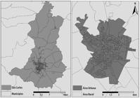
ecological study which considered cases of tuberculosis in the municipality of São Carlos-SP, in the period from 2008 to 2013; spatial scan statistic was applied; the relative risk (RR) and 95% confidence interval (95%CI:) were calculated; the Social Vulnerability Index of São Paulo State was used to characterize the clusters.
RESULTS:
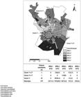
three clusters were identified: two of high risk (RR=7.44; 95%CI: 4.73;11.65 / RR=6.94; 95%CI: 3.82;12.57) and one of low risk (RR=0.3; 95%CI: 0.35;0.96); all the clusters presented very low and medium vulnerability; in the space-time analysis, two clusters presented high risk (RR=12.6; 95%CI: 7.07;19.58 / RR=11.78; 95%CI: 6.00;21.47), with the same tracts of spatial analysis and classification of social vulnerability.
CONCLUSION:
the results may address to specific actions for tuberculosis control considering the early detection of the cases in the areas with higher transmission of the disease.
Keywords:
Tuberculosis; Spatial Analysis; Epidemiology; Social Vulnerability
 Thumbnail
 Thumbnail
 Thumbnail
 Thumbnail


