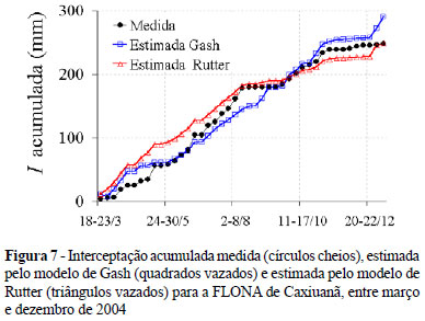
The present work was carried out in the Ferreira Penna Scientific Station, at the Caxiuanã National Forest in Melgaço, Pará, Brazil (01º 42' 30" S; 51º 31'45" W; 60 m of altitude) in the EasternAmazonia. It is an upland forest area with closed vegetation, 35 m average canopy high, some emergent trees with 50 m high and species density between 450 and 550 plants per hectare. The objective was to compare the estimations of rainfall interception using two numerical models, for the period from March to December of 2004. The measured rainfall interception was 248 mm corresponding to 21.5% of total precipitation (1,153.4 mm) above canopy. The rainfall interception was simulated, by Rutter's and Gash's models, at good level of accuracy. The Gash model overestimated the interception by 17.3% (42.8 mm), while the Rutter model overestimated by only 0.5% (1.1 mm) of the observed interception.
Caxiuanã; Gash and Rutter models; Interception; Tropical rainforest