
ABSTRACT
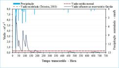
The present work applied the Storm Water Management Model (SWMM) to simulate and evaluate the hydrological response of a coastal river macrodrainage system whose basin is located in an urban-rural transition area and has a tidal influence in its outflow. Thus, as a downstream contour condition, the existing tidal curve in the basin's outlet was reconstructed using the harmonic method. In addition, drainage stretches and sub-basins were automatically delimited, and a land use and occupation maps were developed to obtain the physical and spatial parameters of the drainage elements, these steps being aided by Geographic Information Systems (GIS) tools. The flow was simulated in the system for a period of one month under a moderate precipitation condition. The validation of the model resulted in a Nash-Sutcliffe coefficient of 0.57. The results showed that the SWMM simulated the flows in the drainage stretches of the rural sub-basins with an average deviation of 8.6% of the flows measured in the field. For stretches under tidal influence, SWMM was able to reproduce the effect of the tide in the stretches with a complete oscillation. In addition, the river discharge from the basin to the estuary was 2.35 m3.s-1, on average, and the average monthly flow affluent to the largest reservoir in the basin was 0.33 m3.s-1, consistently with previous work carried out in the study basin. In summary, the results obtained and the proposed model have the potential to assist in the integrated management of rural, urban, and coastal waters.
Keywords:
rainfall-runoff transformation; urban macro-drainage; Geographic Information Systems; semi-distributed model; tidal effect
 Thumbnail
 Thumbnail
 Thumbnail
 Thumbnail
 Thumbnail
 Thumbnail
 Thumbnail
 Thumbnail
 Thumbnail
 Thumbnail
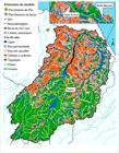
 Fonte: elaboração própria.
 Fonte: elaboração própria.
 Fonte: elaboração própria.
 Fonte: elaboração própria.
 Fonte: elaboração própria.
 Fonte: elaboração própria.
 Fonte: elaboração própria.
 Fonte: elaboração própria.
 Fonte: elaboração própria.
 Fonte: elaboração própria.