Abstract
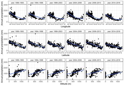
Precipitation is an important object of study and plays an important role in the dynamics of rainfall distribution in a region. This study investigated the spatial and temporal variation of precipitation in the São Francisco River Basin (SFRB). A historical series of data from 1989 to 2018 was analyzed, and a random function was decomposed into trend and residual components for analysis of precipitation. Interpolation techniques were used to analyze precipitation spatial behavior over time, using high-resolution precipitation maps. Our results showed that the exponential model prevailed in four periods. The findings also showed a high precipitation variability in the SFRB and enabled us to monitor precipitation behavior over the years, as well as in the different sub-regions in SFRB. Finally, important information was obtained, enabling, for instance, the identification of vulnerable areas suffering from lack of rainfall.
Keywords:
kriging; R software; variogram
 Thumbnail
 Thumbnail
 Thumbnail